duckdbfs is a simple wrapper around the duckdb package to facilitate working with the construction of a single lazy table (SQL connection) from a set of file paths, URLs, or S3 URIs.
Installation
You can install the development version of duckdbfs from GitHub with:
# install.packages("devtools")
devtools::install_github("cboettig/duckdbfs")
Quickstart
library(duckdbfs)
library(dplyr)
#>
#> Attaching package: 'dplyr'
#> The following objects are masked from 'package:stats':
#>
#>     filter, lag
#> The following objects are masked from 'package:base':
#>
#>     intersect, setdiff, setequal, union
Imagine we have a collection of URLs to files we want to combine into a single tibble in R. The files could be parquet or csv, and some files may have additional columns not present in other files. The combined data may be very large, potentially bigger than available RAM or slow to download completely, but we may only want a subset using methods like dplyr::filter() or dplyr::summarise().
base <- paste0("https://github.com/duckdb/duckdb/raw/main/",
               "data/parquet-testing/hive-partitioning/union_by_name/")
f1 <- paste0(base, "x=1/f1.parquet")
f2 <- paste0(base, "x=1/f2.parquet")
f3 <- paste0(base, "x=2/f2.parquet")
urls <- c(f1,f2,f3)
We can easily access this data without downloading by passing a vector of URLs. Note that if schemas (column names) do not match, we must explicitly request duckdb join the two schemas. Leave this as default, FALSE when not required to achieve much better performance.
ds <- open_dataset(urls, unify_schemas = TRUE)
ds
#> # Source:   table<f1> [3 x 4]
#> # Database: DuckDB v0.10.1 [unknown@Linux 6.6.10-76060610-generic:R 4.3.2/:memory:]
#>       i     j     x     k
#>   <int> <int> <dbl> <int>
#> 1    42    84     1    NA
#> 2    42    84     1    NA
#> 3    NA   128     2    33
Use filter(), select(), etc from dplyr to subset and process data – any method supported by dbpylr. Then use dplyr::collect() to trigger evaluation and ingest results of the query into R.
S3-based access
We can also access remote data over the S3 protocol. An advantage of S3 is that unlike https, it can discover all files in a given folder, so we don’t have to list them individually. This is particularly convenient for accessing large, partitioned datasets, like GBIF: (nearly 200 GB of data split across more than 2000 parquet files)
parquet <- "s3://gbif-open-data-us-east-1/occurrence/2023-06-01/occurrence.parquet"
duckdb_s3_config()
gbif <- open_dataset(parquet, anonymous = TRUE, s3_region="us-east-1")
The additional configuration arguments are passed to the helper function duckdb_s3_config() to set access credentials and configure other settings, like alternative endpoints (for use with S3-compliant systems like minio). Of course it also possible to set these ahead of time by calling duckdb_s3_config() directly. Many of these settings can also be passed along more compactly using the URI query notation found in the arrow package. For instance, we can request anonymous access to a bucket on an alternative endpoint as:
efi <- open_dataset("s3://anonymous@neon4cast-scores/parquet/aquatics?endpoint_override=data.ecoforecast.org")Spatial data
duckdb can also understand a wide array of spatial data queries for spatial vector data, similar to operations found in the popular sf package. See the list of supported functions for details. Most spatial query operations require an geometry column that expresses the simple feature geometry in duckdb’s internal geometry format (nearly but not exactly WKB).
Generating spatial data from tabular
A common pattern will first generate the geometry column from raw columns, such as latitude and lognitude columns, using the duckdb implementation of the a method familiar to postgis, st_point:
spatial_ex <- paste0("https://raw.githubusercontent.com/cboettig/duckdbfs/",
                     "main/inst/extdata/spatial-test.csv") |>
  open_dataset(format = "csv")

spatial_ex |>
  mutate(geometry = st_point(longitude, latitude)) |>
  mutate(dist = st_distance(geometry, st_point(0,0))) |>
  to_sf(crs = 4326)
#> Simple feature collection with 10 features and 4 fields
#> Geometry type: POINT
#> Dimension:     XY
#> Bounding box:  xmin: 1 ymin: 1 xmax: 10 ymax: 10
#> Geodetic CRS:  WGS 84
#>    site latitude longitude      dist          geom
#> 1     a        1         1  1.414214   POINT (1 1)
#> 2     b        2         2  2.828427   POINT (2 2)
#> 3     c        3         3  4.242641   POINT (3 3)
#> 4     d        4         4  5.656854   POINT (4 4)
#> 5     e        5         5  7.071068   POINT (5 5)
#> 6     f        6         6  8.485281   POINT (6 6)
#> 7     g        7         7  9.899495   POINT (7 7)
#> 8     h        8         8 11.313708   POINT (8 8)
#> 9     i        9         9 12.727922   POINT (9 9)
#> 10    j       10        10 14.142136 POINT (10 10)
Note that when coercing generic tabular such as CSV into spatial data, the user is responsible for specifying the coordinate reference system (crs) used by the columns. For instance, in this case our data is latitude-longitude, so we specify the corresponding EPSG code. This is optional (sf allows objects to have unknown CRS), but advisable.
Recall that when used against any sort of external database like duckdb, most dplyr functions like dplyr::mutate() are being transcribed into SQL by dbplyr, and not actually ever run in R. This allows us to seamlessly pass along spatial functions like st_point, despite this not being an available R function. (Also note that SQL is not case-sensitive, so this function is also written as ST_Point). Optionally, we can do additional operations on this geometry column, such as computing distances (st_distance shown here), spatial filters, and so forth. The to_sf() coercion will parse its input into a SQL query that gets passed to duckdb, and the return object will be collected through sf::st_read, returning an (in-memory) sf object.
For more details including a complete list of the dozens of spatial operations currently supported and notes on performance and current limitations, see the duckdb spatial docs
Reading spatial vector files
The duckdb spatial package can also use GDAL to read large spatial vector files. This includes support for remote files. This means that we can easily subset columns from a wide array of potentially remote file types and filter on rows and columns, and perform many spatial operations without ever reading the entire objects into memory in R.
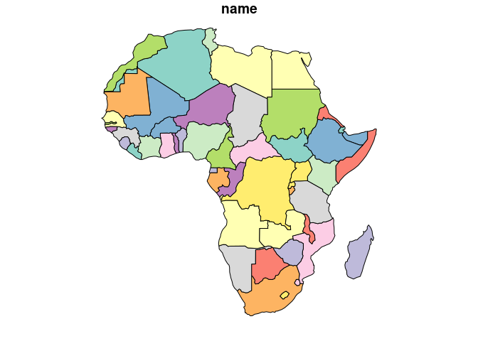
url <- "https://github.com/cboettig/duckdbfs/raw/main/inst/extdata/world.fgb"
countries <- open_dataset(url, format = "sf")
Note that open_dataset() always returns a lazy remote table – we have not yet downloaded the data, let alone read it into R. We simply have a connection allowing us to stream the data.
We can examine the spatial metadata associated with this remote dataset using the duckdbfs spatial helper function, st_read_meta,
countries_meta <- st_read_meta(url)
countries_meta
#> # A tibble: 1 × 7
#>   feature_count geom_column_name geom_type     name  code  wkt             proj4
#>           <dbl> <chr>            <chr>         <chr> <chr> <chr>           <chr>
#> 1           177 geom             Multi Polygon EPSG  4326  "GEOGCS[\"WGS … +pro…
Because this is a small dataset, we can bring the entire data into R (in memory) using to_sf(), specifying the CRS indicated in this metadata:
in_mem <- countries |> to_sf(crs = countries_meta$wkt)However, we can also do a wide range of spatial observations without importing the data. This can be particularly helpful when working with very large datasets. For example: which country polygon contains Melbourne?
Note the result is still a lazy read, we haven’t downloaded or read in the full spatial data object.
library(sf)
#> Linking to GEOS 3.12.1, GDAL 3.8.4, PROJ 9.4.0; sf_use_s2() is TRUE
melbourne <- st_point(c(144.9633, -37.814)) |> st_as_text()

countries |>
  filter(st_contains(geom, ST_GeomFromText({melbourne})))
#> # Source:   SQL [1 x 16]
#> # Database: DuckDB v0.10.1 [unknown@Linux 6.6.10-76060610-generic:R 4.3.2/:memory:]
#>   iso_a3 name      sovereignt continent    area  pop_est pop_est_dens economy
#>   <chr>  <chr>     <chr>      <chr>       <dbl>    <dbl>        <dbl> <chr>
#> 1 AUS    Australia Australia  Oceania   7682300 21262641         2.77 2. Develo…
#> # ℹ 8 more variables: income_grp <chr>, gdp_cap_est <dbl>, life_exp <dbl>,
#> #   well_being <dbl>, footprint <dbl>, inequality <dbl>, HPI <dbl>, geom <list>
As before, we use to_sf() to read in the query results as a native (in-memory) sf object:
Spatial joins
One very common operation are spatial joins, which can be a very powerful way to subset large data. Lets consider a set of point geometries representing the coordinates of major cities around the world:
url_cities <- "https://github.com/cboettig/duckdbfs/raw/spatial-read/inst/extdata/metro.fgb"
cities <- open_dataset(url_cities, format="sf")
Note that metadata must be read directly from the source file, it is not embedded into the duckdb table view. Before combining this data with the countries data, we confirm that the CRS is the same for both datasets:
countries_meta$proj4
#> [1] "+proj=longlat +datum=WGS84 +no_defs"
st_read_meta(url_cities)$proj4
#> [1] "+proj=longlat +datum=WGS84 +no_defs"
For instance, we can return all points (cities) within a collection of polygons (all country boundaries in Oceania continent):
countries |>
   dplyr::filter(continent == "Oceania") |>
   spatial_join(cities, by = "st_intersects", join="inner") |>
   select(name_long, sovereignt, pop2020)
#> # Source:   SQL [6 x 3]
#> # Database: DuckDB v0.10.1 [unknown@Linux 6.6.10-76060610-generic:R 4.3.2/:memory:]
#>   name_long sovereignt  pop2020
#>   <chr>     <chr>         <dbl>
#> 1 Brisbane  Australia   2388517
#> 2 Perth     Australia   2036118
#> 3 Sydney    Australia   4729406
#> 4 Adelaide  Australia   1320783
#> 5 Auckland  New Zealand 1426070
#> 6 Melbourne Australia   4500501
Possible spatial joins include:
| Function | Description |
|---|---|
| st_intersects | Geometry A intersects with geometry B |
| st_disjoint | The complement of intersects |
| st_within | Geometry A is within geometry B (complement of contains) |
| st_dwithin | Geometries are within a specified distance, expressed in the same units as the coordinate reference system. |
| st_touches | Two polygons touch if the that have at least one point in common, even if their interiors do not touch. |
| st_contains | Geometry A entirely contains to geometry B. (complement of within) |
| st_containsproperly | stricter version of st_contains (boundary counts as external) |
| st_covers | geometry B is inside or on boundary of A. (A polygon covers a point on its boundary but does not contain it.) |
| st_overlaps | geometry A intersects but does not completely contain geometry B |
| st_equals | geometry A is equal to geometry B |
| st_crosses | Lines or points in geometry A cross geometry B. |
Note that while SQL functions are not case-sensitive, spatial_join expects lower-case names.
Writing datasets
Like arrow::write_dataset(), duckdbfs::write_dataset() can write partitioned parquet files to local disks and also directly to an S3 bucket. Partitioned writes should take advantage of threading. Partition variables can be specified explicitly, or any dplyr grouping variables will be used by default:
mtcars |> group_by(cyl, gear) |> write_dataset(tempfile())Local files
Of course, open_dataset() and write_dataset() also be used with local files. Remember that parquet format is not required, we can read csv files (including multiple and hive-partitioned csv files).
write.csv(mtcars, "mtcars.csv", row.names=FALSE)
lazy_cars <- open_dataset("mtcars.csv", format = "csv")
Mechanism / motivation
This package simply creates a duckdb connection, ensures the httpfs and spatial extensions are installed if necessary, sets the S3 configuration, and then constructs a VIEW using duckdb’s parquet_scan() or read_csv_auto() methods and associated options. It then returns a dplyr::tbl() for the resulting view. Though straightforward, this process is substantially more verbose than the analogous single function call provided by arrow::open_dataset() due mostly to the necessary string manipulation to construct the VIEW as a SQL statement. I’ve used this pattern a lot, especially when arrow is not an option (http data) or has substantially worse performance (many S3 URIs).
Advanced notes
This is very similar to the behavior of arrow::open_dataset(), with a few exceptions:
- at this time,
arrowdoes not support access over HTTP – remote sources must be in an S3 or GC-based object store. - With local file system or S3 paths,
duckdbcan support “globbing” at any point in the path, e.g.open_dataset(data/*/subdir). (Like arrow,duckdbfs::open_datasetwill assume recursive path discovery on directories). Note that http(s) URLs will always require the full vector since als()method is not possible. Even with URLs or vector-based paths,duckdbcan automatically populate column names given only by hive structure whenhive_style=TRUE(default). Note that passing a vector of paths can be significantly faster than globbing with S3 sources where thels()operation is relatively expensive when there are many partitions.
Performance notes
- In some settings,
duckdbfs::open_datasetcan give substantially better performance (orders of magnitude) thanarrow::open_dataset(), while in other settings it may be comparable or even slower. Package versions, system libraries, network architecture, remote storage performance, network traffic, and other factors can all influence performance, making precise benchmark comparisons in real-world contexts difficult. - On slow network connections or when accessing a remote table repeatedly, it may improve performance to create a local copy of the table rather than perform all operations over the network. The simplest way to do this is by setting the
mode = "TABLE"instead of “VIEW” on open dataset. It is probably desirable to pass a duckdb connection backed by persistent disk location in this case instead of the defaultcached_connection()unless available RAM is not limiting. -
unify_schemais very computationally expensive. Ensuring all files/partitions match schema in advance or processing different files separately can greatly improve performance.